| Hillgrove New South Wales | |
|---|---|
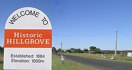
 Hillgrove welcome sign in 2008 | |
| Coordinates | 30°34′S 151°54′E / 30.567°S 151.900°E |
| Population | 174 (SAL 2021)[1] |
| Established | 1884 |
| Postcode(s) | 2350 |
| Elevation | 1,000 m (3,281 ft) |
| Location |
|
| LGA(s) | Armidale Regional Council |
| State electorate(s) | Northern Tablelands |
| Federal division(s) | New England |

Hillgrove is a Northern Tablelands historic goldmining town, now a village with a population of about 95. The village lies about 30 km east of Armidale and 5 km south of the Waterfall Way, at an elevation of 1,000 m on a granite plateau above Bakers Creek, near the Oxley Wild Rivers National Park. It lies in Sandon County, part of the Armidale Regional Council local government area.
Hillgrove was one of the major gold fields in New South Wales, with a recorded production of over 15,000 kg of gold. It has also been a significant producer of antimony (14,700 tons) and tungsten (at least 2,000 tons of scheelite).
- ^ Australian Bureau of Statistics (28 June 2022). "Hillgrove (Armidale Regional - NSW) (suburb and locality)". Australian Census 2021 QuickStats. Retrieved 28 June 2022.
