Hilo International Airport Kahua Mokulele Kauʻāina o Hilo | |||||||||||||||
|---|---|---|---|---|---|---|---|---|---|---|---|---|---|---|---|
 1990 view of ITO with Mauna Kea in the background | |||||||||||||||
| Summary | |||||||||||||||
| Airport type | Public | ||||||||||||||
| Owner/Operator | Hawaii Department of Transportation | ||||||||||||||
| Location | Hilo, Hawaii | ||||||||||||||
| Elevation AMSL | 38 ft / 12 m | ||||||||||||||
| Coordinates | 19°43′13″N 155°02′54″W / 19.72028°N 155.04833°W | ||||||||||||||
| Website | hawaii | ||||||||||||||
| Maps | |||||||||||||||
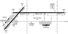
 FAA airport diagram | |||||||||||||||
 | |||||||||||||||
| Runways | |||||||||||||||
| |||||||||||||||
| Statistics (2021) | |||||||||||||||
| |||||||||||||||
Hilo International Airport (IATA: ITO, ICAO: PHTO, FAA LID: ITO), formerly General Lyman Field, is a regional airport located in Hilo, Hawaiʻi, United States.[3] Owned and operated by the Hawaii Department of Transportation, the airport serves windward (eastern) Hawaiʻi island including the districts of Hilo, Hāmākua and Kaʻū, and Puna. It is one of two international airports serving Hawaiʻi island, the other being Kona International Airport on the leeward (western) side.
Although named an international airport, most flights operate between either Honolulu International Airport on Oahu or Kahului Airport on Maui. The airport encompasses 1,007 acres (408 ha) of land.[2][4]
It is included in the Federal Aviation Administration (FAA) National Plan of Integrated Airport Systems for 2021–2025, in which it is categorized as a small-hub primary commercial service facility.[5]
- ^ "Department of Transportation" (PDF). hawaii.gov.
- ^ a b FAA Airport Form 5010 for ITO PDF, effective March 24, 2022.
- ^ Hilo CDP, Hawaii Archived November 24, 2011, at the Wayback Machine." U.S. Census Bureau. Retrieved on May 21, 2009.
- ^ "ITO airport data at skyvector.com". skyvector.com. Retrieved September 12, 2022.
- ^ "List of NPIAS Airports" (PDF). FAA.gov. Federal Aviation Administration. October 21, 2016. Retrieved December 23, 2016.