| Scottish Gaelic name | Hiort |
|---|---|
| Meaning of name | Uncertain |
| Location | |
| OS grid reference | NF092998 |
| Coordinates | 57°49′N 8°35′W / 57.81°N 8.58°W |
| Physical geography | |
| Island group | St Kilda |
| Area | 628.5 ha (1,553 acres) |
| Area rank | 65 [1] |
| Highest elevation | 430 m (1,410 ft) |
| Administration | |
| Council area | Na h-Eileanan Siar |
| Country | Scotland |
| Sovereign state | United Kingdom |
| Demographics | |
| Population | abandoned in 1930 |
| References | [2][3][4][5] |
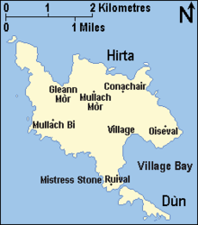
Hirta (Scottish Gaelic: Hiort) is the largest island in the St Kilda archipelago, on the western edge of Scotland. The names Hiort (in Scottish Gaelic) and Hirta (historically in English) have also been applied to the entire archipelago. Now without a permanent resident population, the island had nearly all of St Kilda's population of about 180 residents in the late 17th century and 112 in 1851. It was abandoned in 1930 when the last 36 remaining inhabitants were evacuated to Lochaline on the mainland.[6]
The National Trust for Scotland owns the entire archipelago.[7] It became one of Scotland's six World Heritage Sites in 1986 and is one of the few in the world to hold mixed status for both its natural and cultural qualities.[8] Visits to the island are encouraged during months when the few facilities for tourists are open.[9]
- ^ Area and population ranks: there are c. 300 islands over 20 ha in extent and 93 permanently inhabited islands were listed in the 2011 census.
- ^ National Records of Scotland (15 August 2013). "Appendix 2: Population and households on Scotland's Inhabited Islands" (PDF). Statistical Bulletin: 2011 Census: First Results on Population and Household Estimates for Scotland Release 1C (Part Two) (PDF) (Report). SG/2013/126. Retrieved 14 August 2020.
- ^ Haswell-Smith (2004) p. 315
- ^ Ordnance Survey. OS Maps Online (Map). 1:25,000. Leisure.
- ^ Mac an Tàilleir (2003) p. 107
- ^ "Stories from St Kilda". National Records of Scotland. Retrieved 11 February 2021.
- ^ National Trust for Scotland. Guide. "St Kilda Houses". Archived from the original on 11 March 2013. Retrieved 4 July 2013.
- ^ "World Heritage: United Kingdom of Great Britain and Northern Ireland". UNESCO. Retrieved 3 January 2007.
- ^ "ST KILDA WORLD HERITAGE SITE". NTS. 15 January 2021. Retrieved 10 February 2021.
toilet blocks, shop and camping facilities

