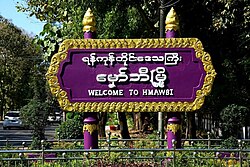
Hmawbi
မှော်ဘီ မြို့နယ် | |
|---|---|
City | |
| Hmawbi Township | |
 Hmawbi Townships | |
 | |
Map of Hmawbi Township(Yangon Region) | |
| Coordinates (District of Hmawbi): 17°06′03″N 96°02′25″E / 17.10083°N 96.04028°E | |
| Country | Myanmar (Burma) |
| Region | Yangon |
| Population (2014)[1] | |
| • Urban | more than 400k |
| Time zone | UTC+6:30 (Myanmar Standard Time or MMT) |
| Area Code | 01 |
| Geocode | Hmawbi |
| ISO 3166 code | MM-06 |
Hmawbi Township (Burmese: မှော်ဘီမြို့နယ်) township is located in northwest of Yangon City. The principal town and administrative seat is Hmawbi.[2]
The Hmawbi airport is at Indan, 4 kilometres (2.5 mi) northeast of the town of Hmawbi.[3]
- ^ http://www.mapnall.com/en/Map-Hmawbi_1574528.html [bare URL]
- ^ "Hmawbi, MM Current Local Time, Time Zone, Hourly Weather and Weather History". cityclock.org. Retrieved 2024-01-12.
- ^ . 2023-02-09 https://web.archive.org/web/20230209165938/https://themimu.info/sites/themimu.info/files/documents/Tsp_Map_VL_Hmawbi_-_Yangon_MIMU154v05_20Apr2020_A1_Eng.pdf. Archived from the original (PDF) on 2023-02-09. Retrieved 2023-02-09.
{{cite web}}: Missing or empty|title=(help)
