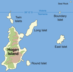
 Map of the Hogan Group | |
Location of Hogan Group in the Bass Strait, north of Tasmania | |
| Etymology | Michael Hogan |
|---|---|
| Geography | |
| Location | Bass Strait |
| Coordinates | 39°15′S 146°59′E / 39.250°S 146.983°E |
| Archipelago | Hogan Group |
| Total islands | 6-8[1] |
| Major islands | Hogan Island |
| Highest elevation | 130 m (430 ft)[2] |
| Administration | |
Australia | |
| State | Victoria |
| State | Tasmania |
The Hogan Group is a collection of six (to eight[1]) islands and islets located in the Bass Strait that define part of the border between mainland Australia and the island state of Tasmania. Within the jurisdiction of Tasmania, the Hogan Group forms a land border between the states of Tasmania and Victoria. The island group is officially designated unallocated Crown land,[3] within the Flinders Municipality in Tasmania and the South Gippsland Shire in Victoria.
The Hogan Group comprises the Hogan Island, Twin, Long, Round, East, Boundary (or North East) islets, and Seal Rock.
- ^ a b Cite error: The named reference
Historywas invoked but never defined (see the help page). - ^ "Bass Strait Islands". Marine Life Network. Retrieved 11 July 2014.
- ^ "Tasmania's islands – land tenure and access issues" (PDF). July 2005. p. 6. Archived from the original (PDF) on 14 July 2014. Retrieved 11 July 2014.
