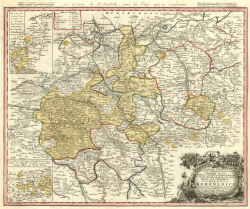
County (Principality) of Hohenlohe Grafschaft (Fürstentum) Hohenlohe | |||||||||
|---|---|---|---|---|---|---|---|---|---|
| 1450–1806 | |||||||||
 Hohenlohe state, Homann, 1748 | |||||||||
| Status | State of the Holy Roman Empire | ||||||||
| Capital | Öhringen | ||||||||
| Religion | Catholic Lutheran | ||||||||
| Government | Monarchy | ||||||||
| History | |||||||||
• Established | 1450 | ||||||||
| 13 May | |||||||||
| 1500 | |||||||||
| 21 May 1744 | |||||||||
| 12 July 1806 | |||||||||
| |||||||||
The House of Hohenlohe (pronounced [hoːənˈloːə]) is a German princely dynasty. It formerly ruled an immediate territory within the Holy Roman Empire, which was divided between several branches. In 1806, the area of Hohenlohe was 1,760 km² and its estimated population was 108,000.[1] The motto of the house is Ex flammis orior (Latin for 'From flames I rise'). The Lords of Hohenlohe were elevated to the rank of Imperial Counts in 1450, and from 1744, the territory and its rulers were princely. In 1825, the German Confederation recognized the right of all members of the house to be styled as Serene Highness (German: Durchlaucht), with the title of Fürst for the heads of its branches, and the title of prince/princess for the other members.[2] From 1861, the Hohenlohe-Öhringen branch was also of ducal status as dukes of Ujest.
Due to the continuous lineage of the dynasty until the present time, it is considered to be one of the longest-lived noble families in Germany and Europe. The large state coat of arms of Baden-Württemberg today bears the Frankish rake of the former Duchy of East and West Franconia, which also included the Franconian region of Baden-Württemberg around Heilbronn-Hohenlohe. The dynasty is related to the Staufers around the famous Emperor Barbarossa, and also to the British royal family through Prince Philip, Duke of Edinburgh, Princess Alexandra of Saxe-Coburg and Gotha and Queen Victoria's half-sister Princess Feodora of Leiningen.
- ^ "Map of Baden-Wurttemberg 1789 - Northern Part". hoeckmann.de.
- ^ Almanach de Gotha: 1910, pages 140-148.
