This article needs additional citations for verification. (July 2023) |
| Hoia Baciu Forest Romanian: Pădurea Hoia-Baciu Hungarian: Hója erdő | |
|---|---|
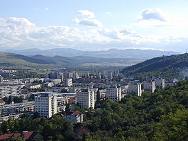
 Southern slope of Hoia Hill (right), Grigorescu (left), and the valley of the Someșul Mic River (background) | |
| Map | |
Location in Romania | |
| Geography | |
| Location | Cluj County, Transylvania, Romania |
| Coordinates | 46°46′26″N 23°31′19″E / 46.774°N 23.522°E |
| Area | 295 hectares (729.0 acres) |
| Administration | |
| Website | www |
The Hoia-Baciu Forest (Romanian: Pădurea Hoia-Baciu, Hungarian: Hója erdő) is a forest situated to the west of the city of Cluj-Napoca, near the open-air section of the Ethnographic Museum of Transylvania. The forest is used as a common recreation destination. In recent years a biking park has been added to the forest, along with areas for other sports such as paintball, airsoft and archery.
