Hornby | |
|---|---|
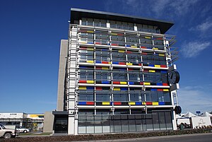
 The Hornby Clocktower building in 2011, a landmark of the suburb prior to its demolition in 2014 | |
 | |
| Coordinates: 43°33′S 172°32′E / 43.550°S 172.533°E | |
| Country | New Zealand |
| City | Christchurch |
| Local authority | Christchurch City Council |
| Electoral ward | Hornby[1] |
| Community board | Waipuna Halswell-Hornby-Riccarton |
| Area | |
| • Land | 1,199 ha (2,963 acres) |
| Population (June 2024)[3] | |
| • Total | 8,790 |
| Hei Hei | Sockburn | |
| Islington |
|
Wigram |
| Prebbleton | Aidanfield |
Hornby is a major residential and retail suburb at the western edge of Christchurch, New Zealand. The suburb is directly connected to other parts of Christchurch and the South Island by a number of main arterial routes, including State Highway 1 and the Christchurch Southern Motorway.
- ^ "Wards, Councillors and Community Boards map". ccc.govt.nz. Christchurch City Council. Retrieved 14 August 2020.
- ^ Cite error: The named reference
Areawas invoked but never defined (see the help page). - ^ "Aotearoa Data Explorer". Statistics New Zealand. Retrieved 26 October 2024.