| Hornchurch | |
|---|---|
| Urban district | |
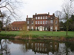
 Langtons House was used as the council offices from 1929. | |
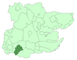
 Hornchurch within Essex in 1961 | |
| Area | |
| • 1931 | 6,783 acres (27.4 km2) |
| • 1961 | 19,768 acres (80.0 km2) |
| • Coordinates | 51°33′58″N 0°13′01″E / 51.566°N 0.217°E |
| Area transferred | |
| • 1934 | All of Rainham and Wennington and parts of Cranham, Great Warley and Upminster from Romford Rural District |
| • 1936 | Part of North Ockendon from Orsett Rural District |
| Population | |
| • 1931 | 28,417 |
| • 1961 | 131,014 |
| Density | |
| • 1931 | 4/acre |
| • 1961 | 6.6/acre |
| History | |
| • Origin | Hornchurch civil parish |
| • Created | 1926 |
| • Abolished | 1965 |
| • Succeeded by | London Borough of Havering |
| Status | Urban district |
| Government | Hornchurch Urban District Council |
| • HQ | Langtons House, Hornchurch |
| • Motto | A good name endureth |
 Coat of arms of Hornchurch Urban District Council | |
| Today part of | London Borough of Havering |
Hornchurch was a local government district in southwest Essex from 1926 to 1965, formed as an urban district for the civil parish of Hornchurch. It was greatly expanded in 1934 with the addition of Cranham, Great Warley, Rainham, Upminster and Wennington; and in 1936 by gaining North Ockendon. Hornchurch Urban District Council was based at Langtons House in Hornchurch from 1929. The district formed a suburb of London and with a population peaking at 131,014 in 1961, it was one of the largest districts of its type in England. It now forms the greater part of the London Borough of Havering in Greater London.