Horqin Left Rear Banner
科尔沁左翼后旗 • ᠬᠣᠷᠴᠢᠨ ᠵᠡᠭᠦᠨ ᠭᠠᠷᠤᠨ ᠬᠣᠶᠢᠲᠤ ᠬᠣᠰᠢᠭᠤ | |
|---|---|
 Grasslands near Agula Town | |
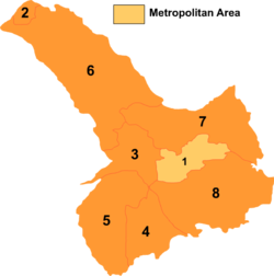
 Tongliao divisions: Horqin Left Rear Banner is 8 on this map | |
| Coordinates: 42°57′N 122°21′E / 42.950°N 122.350°E | |
| Country | China |
| Autonomous region | Inner Mongolia |
| Prefecture-level city | Tongliao |
| Banner seat | Ganjig |
| Area | |
| • Total | 11,500 km2 (4,400 sq mi) |
| Elevation | 250 m (820 ft) |
| Population (2020)[1] | |
| • Total | 321,438 |
| • Density | 28/km2 (72/sq mi) |
| Time zone | UTC+8 (China Standard) |
| Website | www |
| Horqin Left Rear Banner | |||||||
|---|---|---|---|---|---|---|---|
| Chinese name | |||||||
| Simplified Chinese | 科尔沁左翼后旗 | ||||||
| Traditional Chinese | 科爾沁左翼後旗 | ||||||
| |||||||
| Mongolian name | |||||||
| Mongolian Cyrillic | Хорчин зүүн гарын хойд хошуу | ||||||
| Mongolian script | ᠬᠣᠷᠴᠢᠨ ᠵᠡᠭᠦᠨ ᠭᠠᠷᠤᠨ ᠬᠣᠶᠢᠲᠤ ᠬᠣᠰᠢᠭᠤ | ||||||
| |||||||
Horqin Left Rear Banner (Mongolian: ᠬᠣᠷᠴᠢᠨ ᠵᠡᠭᠦᠨ ᠭᠠᠷᠤᠨ ᠬᠣᠶᠢᠲᠤ ᠬᠣᠰᠢᠭᠤ [note 1] ; Chinese: 科尔沁左翼后旗, original Mongolian name Büve vang qosigu[citation needed]) is a banner of southeastern Inner Mongolia, China, bordering Liaoning province to the south. It is under the administration of Tongliao City, 75 kilometres (47 mi) to the north and its banner seat is the town of Ganjig. The local Mongolian dialect is Khorchin Mongolian.
Cite error: There are <ref group=note> tags on this page, but the references will not show without a {{reflist|group=note}} template (see the help page).

