Housatonic, Massachusetts | |
|---|---|
 Railroad tracks along the Housatonic River at Housatonic | |
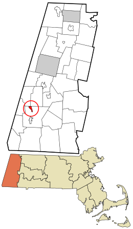
 Location in Berkshire County and the state of Massachusetts. | |
| Coordinates: 42°15′8″N 73°22′3″W / 42.25222°N 73.36750°W | |
| Country | United States |
| State | Massachusetts |
| County | Berkshire |
| Town | Great Barrington |
| Area | |
| • Total | 0.98 sq mi (2.53 km2) |
| • Land | 0.89 sq mi (2.31 km2) |
| • Water | 0.09 sq mi (0.22 km2) |
| Elevation | 735 ft (224 m) |
| Population (2020) | |
| • Total | 1,083 |
| • Density | 1,215.49/sq mi (469.17/km2) |
| Time zone | UTC-5 (Eastern (EST)) |
| • Summer (DST) | UTC-4 (EDT) |
| ZIP code | 01236 |
| Area code | 413 |
| FIPS code | 25-31295 |
| GNIS feature ID | 0607478 |
Housatonic is a census-designated place (CDP) in the town of Great Barrington in Berkshire County, Massachusetts, United States. It is part of the Pittsfield, Massachusetts Metropolitan Statistical Area. The population was 1,109 at the 2010 census.[2] It was named after the Housatonic River.[3]
- ^ "2020 U.S. Gazetteer Files". United States Census Bureau. Retrieved May 21, 2022.
- ^ "Geographic Identifiers: 2010 Demographic Profile Data (G001): Housatonic CDP, Massachusetts". U.S. Census Bureau, American Factfinder. Archived from the original on February 12, 2020. Retrieved December 20, 2013.
- ^ Gannett, Henry (1905). The Origin of Certain Place Names in the United States. Govt. Print. Off. pp. 161.