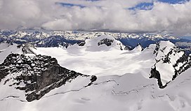
| Howser Peak | |
|---|---|
 North aspect, centered (Marmolata left and Flattop right) | |
| Highest point | |
| Elevation | 3,094 m (10,151 ft)[1] |
| Prominence | 262 m (860 ft)[2] |
| Parent peak | Howser Spire (3,412 m)[3] |
| Isolation | 2.96 km (1.84 mi)[4] |
| Listing | Mountains of British Columbia |
| Coordinates | 50°42′17″N 116°47′01″W / 50.70472°N 116.78361°W[5] |
| Geography | |
| Country | Canada |
| Province | British Columbia |
| District | Kootenay Land District |
| Protected area | Bugaboo Provincial Park |
| Parent range | Purcell Mountains The Bugaboos[2] |
| Topo map | NTS 82K10 Howser Creek |
| Geology | |
| Rock age | 135 Million years ago[6] |
| Rock type | Granodiorite[6] |
| Climbing | |
| First ascent | 1916 by Conrad Kain |
Howser Peak is a 3,094-metre (10,151-foot) summit in The Bugaboos of British Columbia, Canada. It is located south of the Bugaboo Glacier and is the southernmost point of Bugaboo Provincial Park.[7] Precipitation runoff from Howser Peak drains north into Bugaboo Creek which is a tributary of the Columbia River; as well as south to Duncan River via Howser Creek. Howser Peak is more notable for its steep rise above local terrain than for its absolute elevation as topographic relief is significant with the south aspect rising 1,380 meters (4,527 ft) in 2.5 km (1.6 mi).
- ^ Glen W. Boles, William Lowell Putnam, Roger W. Laurilla (2006), Canadian Mountain Place Names: The Rockies and Columbia Mountains, Rocky Mountain Books, ISBN 9781894765794, p. 127.
- ^ a b "Howser Peak, British Columbia". Peakbagger.com. Retrieved 2023-02-08.
- ^ "Howser Peak, Peakvisor.com". Retrieved 2023-02-08.
- ^ "Howser Peak - 10,111' BC". listsofjohn.com. Retrieved 2023-02-08.
- ^ "Howser Peak". Geographical Names Data Base. Natural Resources Canada. Retrieved 2023-02-08.
- ^ a b Mary Caperton Morton (2017), Aerial Geology; A High-Altitude Tour of North America's Spectacular Volcanoes, Canyons, Glaciers, Lakes, Craters, and Peaks, Timber Press, ISBN 9781604698350, p. 42
- ^ "Howser Peak". BC Geographical Names. Retrieved 2023-02-08.

