| Hudson Bay drainage basin | |
|---|---|
 The Hudson Bay drainage connects primarily to the Labrador Sea just south of Davis Strait, as depicted on most atlases such as those of the National Geographic Society, just north of the 60th parallel north and northeast of the Labrador Peninsula | |
| Area | 3,861,400 km2 (1,490,900 sq mi) |
| Geology | |
| Type | Drainage basin |
| Geography | |
| Location | North America |
| Country | |
| Coordinates | 60°N 86°W / 60°N 86°W |
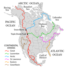
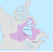
The Hudson Bay drainage basin is the drainage basin in northern North America where surface water empties into the Hudson Bay[1] and adjoining waters. Spanning an area of about 3,861,400 square kilometres (1,490,900 sq mi) and with a mean discharge of about 30,900 m3/s (1,090,000 cu ft/s),[2] the basin is almost entirely within Canada. It encompasses parts of the Canadian Prairies, Central Canada, and Northern Canada. A small area of the basin is in the northern part of the Midwestern United States.

The Hudson Bay drainage basin coincides almost completely with the former territory of Rupert's Land, claimed by the Hudson's Bay Company in the 17th century. It was an ideal area for the early North American fur trade.[3]
- ^ "Hudson Bay". Canadian Geographical Names Database. Government of Canada. Retrieved 10 April 2024.
- ^ "Canada Drainage Basins". The National Atlas of Canada, 5th edition. Natural Resources Canada. 1985. Archived from the original on 4 March 2011. Retrieved 24 November 2010.
- ^ McIntosh, Andrew; Smith, Shirlee Anne (7 February 2006). "Rupert's Land". The Canadian Encyclopedia. Retrieved 11 April 2024.