Hudson Valley Regional Airport | |||||||||||||||||||
|---|---|---|---|---|---|---|---|---|---|---|---|---|---|---|---|---|---|---|---|
 | |||||||||||||||||||
 | |||||||||||||||||||
| Summary | |||||||||||||||||||
| Airport type | Public | ||||||||||||||||||
| Owner | Dutchess County | ||||||||||||||||||
| Serves | Poughkeepsie, New York | ||||||||||||||||||
| Location | Town of Wappinger[1] | ||||||||||||||||||
| Elevation AMSL | 164 ft / 50 m | ||||||||||||||||||
| Coordinates | 41°37′36″N 073°53′03″W / 41.62667°N 73.88417°W | ||||||||||||||||||
| Website | POU Website | ||||||||||||||||||
| Maps | |||||||||||||||||||
 FAA airport diagram | |||||||||||||||||||
 | |||||||||||||||||||
| Runways | |||||||||||||||||||
| |||||||||||||||||||
| Statistics (2014) | |||||||||||||||||||
| |||||||||||||||||||
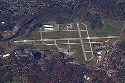
Hudson Valley Regional Airport (IATA: POU, ICAO: KPOU, FAA LID: POU), formerly known as Dutchess County Airport, is a county-owned public-use airport located on State Route 376 in the Town of Wappinger,[1] Dutchess County, New York, United States, 4 miles (6.4 km) south of the central business district of Poughkeepsie.[2] It is sometimes called Poughkeepsie Airport, which gives it the code POU. The airport provides corporate and general aviation transportation services.
- ^ a b "2020 CENSUS - CENSUS BLOCK MAP (INDEX): Wappinger town, NY" (PDF). U.S. Census Bureau. p. 1 (PDF p. 2/4). Retrieved 2024-09-23.
Dutchess County Arprt
(see aircraft symbol) - ^ a b FAA Airport Form 5010 for POU PDF, effective 2015-06-25