| Hula Lake | |
|---|---|
| אגמון החולה | |
 Hula Lake | |
| Location | Northern Israel |
| Type | Fresh water lake |
| Basin countries | Israel |
| Max. length | 5.5 km |
| Max. width | 4.5 km |
| Max. depth | 6 meters |
lengthUnconverted dimensions in
widthUnconverted dimensions in
max-depth(Infobox body of water).
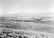
Hula Lake (also known as Somchi sea, Sovechi sea, or Water of Merom) was a freshwater lake in the southern part of the Hula Valley in northern Israel. The lake, located on Great Syrian-African rift, was part of the Jordan River system and was drained in the 1950s.[1] The lake covered an area of about 14 square kilometers, with marshes to the north covering an additional 30 square kilometers, and further areas that were flooded in the winter, expanding the marshlands.
The lake and its marshes served as an important habitat for a wide variety of plants and animals, many of which are endemic to the area. During the British Mandate period and up until the 1950s, fishing and agricultural activities took place around the lake, and the impact of human settlement caused significant changes to the lake's ecosystem.
In the 1950s, the lake was drained as part of a national project aimed at expanding agricultural land and reducing the incidence of malaria in the region. This move sparked significant public debate due to its environmental and ecological impacts. In recent years, efforts have been made to partially restore the lake and to revive some of the biological diversity that once characterized the area.
Today, the Hula region serves as an important natural and tourist site, attracting visitors from all over the world. Visitor centers provide information and guidance on the lake's history and ecology.

- ^ Gophen, Moshe (2023), Hula Drainage Project, Springer Geography, Cham: Springer International Publishing, pp. 1–11, doi:10.1007/978-3-031-23412-5_1, ISBN 978-3-031-23411-8, retrieved 2024-07-12