| Hungerford Queensland | |||||||||||||||
|---|---|---|---|---|---|---|---|---|---|---|---|---|---|---|---|
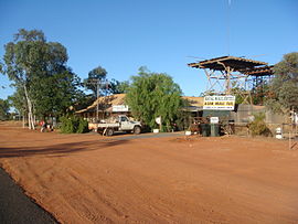
 The view around the Royal Mail Hotel | |||||||||||||||
| Coordinates | 28°59′46″S 144°24′29″E / 28.9961°S 144.4080°E | ||||||||||||||
| Population | 19 (2021 census)[1] | ||||||||||||||
| • Density | 0.00284/km2 (0.00736/sq mi) | ||||||||||||||
| Postcode(s) | 4493 | ||||||||||||||
| Elevation | 130 m (427 ft) | ||||||||||||||
| Area | 6,690.5 km2 (2,583.2 sq mi) | ||||||||||||||
| Time zone | AEST (UTC+10:00) | ||||||||||||||
| Location |
| ||||||||||||||
| LGA(s) | |||||||||||||||
| Region | South West Queensland | ||||||||||||||
| County | Numalla County | ||||||||||||||
| State electorate(s) | Warrego | ||||||||||||||
| Federal division(s) | Maranoa | ||||||||||||||
| |||||||||||||||
Hungerford is an outback town in the Shire of Bulloo and a locality in the Shire of Bulloo and Shire of Paroo, South West Queensland, Australia.[2][3][4] The locality is on the Queensland border with New South Wales (which is also the Dingo fence).[5]
In the 2021 census, the locality of Hungerford had a population of 19 people.[1] The locality of Hungerford on the New South Wales side of the border had a population of 15.[6]
Hungerford will be the site of a total solar eclipse on 22 July 2028.[7]
- ^ a b Cite error: The named reference
Census2021was invoked but never defined (see the help page). - ^ "Hungerford – town in Shire of Bulloo (entry 16466)". Queensland Place Names. Queensland Government. Retrieved 28 December 2017.
- ^ "Hungerford – locality in Shire of Bulloo (entry 42946)". Queensland Place Names. Queensland Government. Retrieved 28 December 2017.
- ^ "Hungerford – locality in Shire of Paroo (entry 42656)". Queensland Place Names. Queensland Government. Retrieved 28 December 2017.
- ^ Cite error: The named reference
:1was invoked but never defined (see the help page). - ^ Cite error: The named reference
Census2016NSWwas invoked but never defined (see the help page). - ^ "Total Solar Eclipse of 2028 Jul 22". NASA. Archived from the original on 24 October 2020. Retrieved 15 December 2018.
