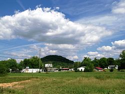
Hunter
Stoney Creek | |
|---|---|
 | |
 Location of Hunter, Tennessee | |
| Coordinates: 36°22′36″N 82°9′18″W / 36.37667°N 82.15500°W | |
| Country | United States |
| State | Tennessee |
| County | Carter |
| Area | |
| • Total | 6.42 sq mi (16.64 km2) |
| • Land | 6.40 sq mi (16.57 km2) |
| • Water | 0.03 sq mi (0.07 km2) |
| Elevation | 1,568 ft (478 m) |
| Population | |
| • Total | 1,803 |
| • Density | 281.85/sq mi (108.83/km2) |
| Time zone | UTC-5 (Eastern (EST)) |
| • Summer (DST) | UTC-4 (EDT) |
| ZIP code | 37643 |
| Area code | 423 |
| FIPS code | 47-36500[3] |
| GNIS feature ID | 1328513[4] |
Hunter (also called Stoney Creek) is a census-designated place (CDP) and unincorporated community located northeast of Elizabethton in Carter County, Tennessee, along Tennessee State Route 91 and the Watauga River. Its population was 1,854 as of the 2010 census.[5] It is part of the Johnson City Metropolitan Statistical Area, which is a component of the Johnson City-Kingsport-Bristol, TN-VA Combined Statistical Area – commonly known as the "Tri-Cities" region. Hunter is a suburb of Elizabethton.
- ^ "ArcGIS REST Services Directory". United States Census Bureau. Retrieved October 15, 2022.
- ^ "Census Population API". United States Census Bureau. Retrieved October 15, 2022.
- ^ "U.S. Census website". United States Census Bureau. Retrieved January 31, 2008.
- ^ "US Board on Geographic Names". United States Geological Survey. October 25, 2007. Retrieved January 31, 2008.
- ^ "U.S. Census website". United States Census Bureau. Retrieved May 14, 2011.