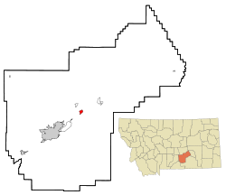
Huntley, Montana | |
|---|---|
 Location of Huntley, Montana | |
| Coordinates: 45°53′59″N 108°18′16″W / 45.89972°N 108.30444°W | |
| Country | United States |
| State | Montana |
| County | Yellowstone |
| Area | |
| • Total | 1.60 sq mi (4.15 km2) |
| • Land | 1.52 sq mi (3.94 km2) |
| • Water | 0.08 sq mi (0.21 km2) |
| Elevation | 3,019 ft (920 m) |
| Population (2020) | |
| • Total | 442 |
| • Density | 290.79/sq mi (112.30/km2) |
| Time zone | UTC-7 (Mountain (MST)) |
| • Summer (DST) | UTC-6 (MDT) |
| ZIP code | 59037 |
| Area code | 406 |
| FIPS code | 30-38200 |
| GNIS feature ID | 2408411[2] |
Huntley is a census-designated place (CDP) in Yellowstone County, Montana, United States. The population was 411 at the 2000 census. Huntley lent its name to the Huntley Project, a federal irrigation project that began delivering water to the arid district in 1907. Today, Huntley is an eastern suburb of Billings and is located east of Shepherd and west of Worden.
- ^ "ArcGIS REST Services Directory". United States Census Bureau. Retrieved September 5, 2022.
- ^ a b U.S. Geological Survey Geographic Names Information System: Huntley, Montana