Hurlford
| |
|---|---|
| Village | |
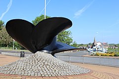
 Hurlford Cross. The propeller was placed on site by Hurlford & Crookedholm Community Council September 1984 to commemorate aspects of working life of communities between mid 19th–20th centuries. | |
Location within East Ayrshire | |
| Population | 4,400 (2022)[1] |
| OS grid reference | NS456366 |
| • Edinburgh | 75 mi (121 km) |
| • London | 404 mi (650 km) |
| Council area | |
| Lieutenancy area | |
| Country | Scotland |
| Sovereign state | United Kingdom |
| Post town | KILMARNOCK |
| Postcode district | KA1, KA3 |
| Dialling code | 01560 01563 |
| Police | Scotland |
| Fire | Scottish |
| Ambulance | Scottish |
| UK Parliament | |
| Scottish Parliament | |
Hurlford (Scottish Gaelic: Baile Àtha Cliath) is a village in East Ayrshire, Scotland, situated on the outskirts of Kilmarnock, the largest and administrative centre of East Ayrshire and East Ayrshire Council. It has a population of 4,968.[2] Hurlford's former names include Whirlford and Hurdleford.[3] The village was named Whirlford as a result of a ford crossing the River Irvine east of Hurlford Cross, near Shawhill.[4] It shares its name in Gaelic, Baile Àtha Cliath ("The Ford of the Hurdles") with the Irish capital Dublin. The census locality is called Hurlford and Crookedholm.[5]
The village's Blair Park is home to Hurlford United F.C. and many notable footballers have been trained there.
- ^ "Mid-2020 Population Estimates for Settlements and Localities in Scotland". National Records of Scotland. 31 March 2022. Retrieved 31 March 2022.
- ^ "Browser Population". Scrol.gov.uk. Archived from the original on 23 February 2012. Retrieved 11 May 2012.
- ^ East Ayrshire Council Minutes, page 217, Item 7[permanent dead link]
- ^ "John helps put Hurlford history on the world map". Kilmarnock Standard. 4 October 2007. Retrieved 11 May 2012.
- ^ "NR Scotland list of localities" (PDF). NRScotland.gov.uk. 2010. Retrieved 19 June 2016.
