Hustadvika Municipality
Hustadvika kommune | |
|---|---|
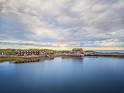
 View of a hotel on the Hustadvika shoreline | |
 Møre og Romsdal within Norway | |
 Hustadvika within Møre og Romsdal | |
| Coordinates: 62°55′00″N 7°13′39″E / 62.916796°N 7.227630°E | |
| Country | Norway |
| County | Møre og Romsdal |
| District | Nordmøre |
| Established | 1 Jan 2020 |
| • Preceded by | Eide and Fræna |
| Administrative centre | Elnesvågen |
| Government | |
| • Mayor (2023) | Nils Christian Harnes (KrF) |
| Area | |
| • Total | 521.93 km2 (201.52 sq mi) |
| • Land | 507.74 km2 (196.04 sq mi) |
| • Water | 14.19 km2 (5.48 sq mi) 2.7% |
| • Rank | #203 in Norway |
| Population (2023) | |
| • Total | 13,341 |
| • Rank | #92 in Norway |
| • Density | 26.3/km2 (68/sq mi) |
| • Change (10 years) | |
| Demonym | Hustadværing[1] |
| Official language | |
| • Norwegian form | Neutral |
| Time zone | UTC+01:00 (CET) |
| • Summer (DST) | UTC+02:00 (CEST) |
| ISO 3166 code | NO-1579[3] |
| Website | Official website |
Hustadvika is a municipality in Møre og Romsdal county, Norway. It is located in the traditional districts of Nordmøre and Romsdal. The administrative centre of the municipality is the village of Elnesvågen. Other villages in the municipality include Hustad, Bud, Tornes, Sylte, Malme, Aureosen, Eide, Lyngstad, Vevang, and Visnes.
The 522-square-kilometre (202 sq mi) municipality is the 203rd largest by area out of the 356 municipalities in Norway. Hustadvika is the 92nd most populous municipality in Norway with a population of 13,341. The municipality's population density is 26.3 inhabitants per square kilometre (68/sq mi) and its population has increased by 1.9% over the previous 10-year period.[4][5]
- ^ "Navn på steder og personer: Innbyggjarnamn" (in Norwegian). Språkrådet.
- ^ "Forskrift om målvedtak i kommunar og fylkeskommunar" (in Norwegian). Lovdata.no.
- ^ Bolstad, Erik; Thorsnæs, Geir, eds. (26 January 2023). "Kommunenummer". Store norske leksikon (in Norwegian). Kunnskapsforlaget.
- ^ Statistisk sentralbyrå. "Table: 06913: Population 1 January and population changes during the calendar year (M)" (in Norwegian).
- ^ Statistisk sentralbyrå. "09280: Area of land and fresh water (km²) (M)" (in Norwegian).
