Hyde Park Township | |
|---|---|
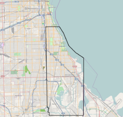
 The original boundaries of Hyde Park Township, imposed on a current map of Chicago | |
 | |
| Coordinates: 41°44′03″N 87°34′32″W / 41.7343°N 87.5756°W | |
| Country | United States |
| State | Illinois |
| County | Cook |
| Organized | 1861 |
| Elevation | 591 ft (180 m) |
| Population (1889) | |
• Total | 85,000 |
| Time zone | UTC-6 (CST) |
| • Summer (DST) | UTC-5 (CDT) |
Hyde Park Township is a former civil township in Cook County, Illinois, United States that existed as a separate municipality from 1861 until 1889 when it was annexed into the city of Chicago.[1] Its borders are Pershing Road (formerly 39th Street) on the north, State Street on the west, Lake Michigan and the Indiana state line on the east, and 138th Street and the Calumet River on the south.[2] This region comprised much of what is now known as the South Side of Chicago.
During Chicago's initial explosive growth, it developed from an adjacent swampy area to a full-fledged residential, commercial and resort community. However, due to infrastructure limitations, legislative incentives and the lure of better municipal services it, along with numerous adjoining townships, agreed to be annexed into the city of Chicago, creating the largest city in the United States at that time.
- ^ Keating, Ann Durkin (2005). "Hyde Park Township". The Electronic Encyclopedia of Chicago. Chicago Historical Society. Retrieved July 19, 2007.
- ^ Keating, Ann Durkin (2005). "Annexations and Additions to the City of Chicago". The Electronic Encyclopedia of Chicago. Chicago Historical Society. Retrieved July 18, 2007.