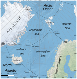
| Iceland Sea | |
|---|---|
 Borders of Iceland Sea according to IHO draft standard (2002) | |
| Coordinates | 66°55′23″N 12°37′44″W / 66.923107°N 12.628921°W |
| Surface area | 406,000 km2 (157,000 sq mi) |
| Average depth | 1,026 m (3,366 ft) |
| Water volume | 417,000 km3 (100,000 cu mi) |
| Islands | None |
The Iceland Sea, a relatively small body of water, is bounded by Iceland. It is characterized by its proximity to the Mid-Atlantic Ridge, which transforms into the Kolbeinsey Ridge, and the Greenland-Scotland Ridge, and it lies just south of the Arctic Circle.[1] This region is typically delineated by Greenland to the west, the Denmark Strait, and the continental shelf break south of Iceland to the south.[2] Next in the boundary line are Jan Mayen, being a small Norwegian volcanic island, and the Jan Mayen Fracture Zone to the north, with the Jan Mayen Ridge to the east of the sea.[2][3][4] This ridge serves as the northern boundary of the Iceland Sea, acting as the dividing line from the Greenland Sea.[1] To the immediate south of Jan Mayen, the Iceland-Jan Mayen Ridge stretches towards the Iceland-Faroe Ridge, creating a boundary between the Iceland Sea and the Norwegian Sea to the east.[1]
There were changes regarding the limits of the Iceland Sea as according to the International Hydrographic Organization, in its 1953 edition of the Limits of Oceans and Seas standard, the Greenland Sea comprises the entire area of the Iceland Sea.[5] However in the proposed 2002 edition, the Iceland sea is now a defined zone of its own.[6]
- ^ a b c Astthorsson, Olafur S.; Gislason, Astthor; Jonsson, Steingrimur (November 5, 2007). "Climate variability and the Icelandic marine ecosystem". Deep Sea Research Part II: Topical Studies in Oceanography. 54 (23–26): 2456–2477. doi:10.1016/j.dsr2.2007.07.030. ISSN 0967-0645 – via Science Direct.
- ^ a b Pálsson, Ólafur K.; Gislason, Astthor; Guðfinnsson, Hafsteinn G.; Gunnarsson, Björn; Ólafsdóttir, Sólveig R.; Petursdottir, Hildur; Sveinbjörnsson, Sveinn; Thorisson, Konrad; Valdimarsson, Héðinn (May 5, 2012). "Ecosystem structure in the Iceland Sea and recent changes to the capelin (Mallotus villosus) population". ICES Journal of Marine Science. 69 (7): 1242–1254. doi:10.1093/icesjms/fss071. ISSN 1095-9289.
- ^ "Jan Mayen". Britannica. January 12, 2024.
- ^ Gislason, Astthor; Silva, Teresa (May 18, 2012). "Abundance, composition, and development of zooplankton in the Subarctic Iceland Sea in 2006, 2007, and 2008". academic.oup.com. ICES Journal of Marine Science. doi:10.1093/icesjms/fss070.
- ^ "Limits of the Oceans and Seas". Nature. 172: 484. September 12, 1953. doi:10.1038/172484b0. ISSN 0028-0836 – via Nature.
- ^ International Hydrographic Organization (June 2002). "Names and Limits of Oceans and Seas". IHO PUBLICATION S-23.
