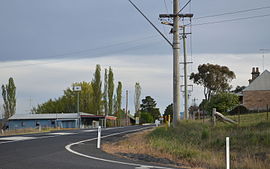
Ilford is a village in New South Wales, Australia, beside the Crudine River within the Mid-Western Regional Council. It is located on the Castlereagh Highway (locally referred to as the 'Sydney Road'), about 220 kilometres north-west of Sydney. At the 2016 census Ilford and the surrounding rural district had a population of 187, living in 65 private dwellings. The district also included 43 unoccupied private dwellings.[1] Ilford was named after the English township of Ilford (in Essex, now a part of Greater London), from where early residents of the locality originated.
Unremarkable in appearance, Ilford appears to the traveller as no more than a cluster of buildings around a T-junction on the 'Sydney Road', where the Bathurst-Ilford Road joins the Castlereagh Highway. The focus of the community is Ilford Public School on the outskirts of the road-side settlement.[2] An information bay with toilet facilities is located on the northern edge of the village.
- ^ a b "Ilford". 2016 Census Quick Stats. Australian Bureau of Statistics. Retrieved 20 March 2021.
- ^ "Ilford Public School". NSW Department of Education. Retrieved 20 March 2021.

