| Illinois River | |
|---|---|
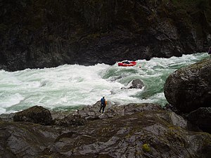
 Rafting the Green Wall Rapids on the Illinois River | |
Location of the mouth of the Illinois River in Oregon | |
| Etymology | The U.S. state of Illinois, the birthplace of three brothers named Althouse who emigrated to Oregon and mined for gold along Althouse Creek and the Illinois River[2] |
| Location | |
| Country | United States |
| State | Oregon |
| County | Josephine and Curry |
| Physical characteristics | |
| Source | Confluence of East Fork Illinois River and West Fork Illinois River |
| • location | near Cave Junction, Josephine County, Oregon |
| • coordinates | 42°09′35″N 123°39′33″W / 42.15972°N 123.65917°W[1] |
| • elevation | 1,271 ft (387 m)[3] |
| Mouth | Rogue River |
• location | Agness, Curry County, Oregon |
• coordinates | 42°33′00″N 124°03′58″W / 42.55000°N 124.06611°W[1] |
• elevation | 102 ft (31 m)[1] |
| Length | 56 mi (90 km)[4][Note 1] |
| Basin size | 983 sq mi (2,550 km2)[5] |
| Discharge | |
| • location | near Kerby, 50.3 miles (81.0 km) from the mouth[6] |
| • average | 1,262 cu ft/s (35.7 m3/s)[6] |
| • minimum | 121 cu ft/s (3.4 m3/s) |
| • maximum | 92,200 cu ft/s (2,610 m3/s) |
| Type | Wild, Scenic, Recreational |
| Designated | October 19, 1984 |
The Illinois River is a tributary, about 56 miles (90 km) long, of the Rogue River in the U.S. state of Oregon. It drains part of the Klamath Mountains in northern California and southwestern Oregon. The river's main stem begins at the confluence of its east and west forks near Cave Junction in southern Josephine County. Its drainage basin includes Sucker Creek, which rises in the Red Buttes Wilderness, near Whiskey Peak on the California state line. The main stem flows generally northwest in a winding course past Kerby and through the Siskiyou National Forest and Kalmiopsis Wilderness. It joins the Rogue River from the south at Agness 4.75 miles NW of the Curry–Josephine county line, (US Geological Survey National Map measure tool) and 27 miles (43 km) from the Pacific Ocean, 16.8 miles as the crow flies.
The river's lower 50.4 miles (81.1 km), from where it enters the Rogue River–Siskiyou National Forest downstream from Kerby to its confluence with the Rogue River, were designated Wild and Scenic in 1984. Of this, 28.7 miles (46.2 km) is protected as wild, 17.9 miles (28.8 km) as scenic, and 3.8 miles (6.1 km) as recreational.[4]
- ^ a b c "Illinois River". Geographic Names Information System. United States Geological Survey, United States Department of the Interior. 28 November 1980. Retrieved 20 May 2009.
- ^ McArthur, Lewis A.; McArthur, Lewis L. (2003). Oregon Geographic Names (seventh ed.). Portland, Oregon: Oregon Historical Society Press. p. 495. ISBN 0-87595-277-1.
- ^ Source elevation derived from Google Earth search using Geographic Names Information System (GNIS) source coordinates.
- ^ a b "Illinois River, Oregon". National Wild and Scenic Rivers System. Retrieved 23 November 2013.
- ^ Hickman, O. Eugene. "Potential Natural (Historic?) Vegetation of the Central Illinois River Valley". Oregon Department of Fish and Wildlife. Retrieved 22 May 2009. The document is Appendix E of the Illinois Appendices in zipped PDF format.
- ^ a b "Water-Data Report 2007: 14377100 Illinois River near Kerby, OR" (PDF). United States Geological Survey. Retrieved 3 May 2013.
Cite error: There are <ref group=Note> tags on this page, but the references will not show without a {{reflist|group=Note}} template (see the help page).
