| Imja Tse | |
|---|---|
| Island Peak | |
 An island in a sea of ice | |
| Highest point | |
| Elevation | 6,165 m (20,226 ft)[1][2] |
| Listing | Mountains of Nepal |
| Coordinates | 27°55′15″N 86°56′07″E / 27.92079°N 86.93516°E[2] |
| Geography | |
| Country | Nepal |
| Region | Khumbu |
| District | Solukhumbu |
| Protected area | Sagarmatha National Park |
| Parent range | Khumbu Himal |
| Climbing | |
| First ascent | 1956 by Hans-Rudolf Von Gunten and 2 unknown Sherpas |
| Easiest route | North Ridge PD+ glacier/scrambling/ice climbing |
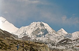
Imja Tse, better known as Island Peak, is a mountain in Sagarmatha National Park in the Himalayas of eastern Nepal. The peak was named Island Peak in 1953 by members of the British Mount Everest expedition because it appears as an island in a sea of ice when viewed from Dingboche.[3] The peak was later renamed in 1983 to Imja Tse but Island Peak remains the popular choice.[4] The peak is actually an extension of the ridge coming down off the south end of Lhotse Shar.
The southwest summit of Imja Tse was first climbed in 1953 as part of a training exercise by a British expedition that went on to summit Mount Everest. The team that climbed Imja Tse comprised Tenzing Norgay, Charles Evans, Alfred Gregory, Charles Wylie and seven other Sherpas. The main summit was first climbed in 1956 by Hans-Rudolf Von Gunten and two unknown Sherpas, members of a Swiss team that went on to make the second ascent of Everest and the first ascent of Lhotse.[5][6]

- ^ "NMA Expedition Peaks". nepalmountaineering.org. Archived from the original on 6 March 2023. Retrieved 8 May 2023.
- ^ a b "Topographic map of Island Peak". opentopomap.org. Retrieved 8 May 2023.
- ^ Wylie, Charles (1954). "Everest, 1953". Himalayan Journal. 18. Retrieved 13 July 2018.
- ^ "Imja Tse". Nepal Mountaineering Association. Retrieved 23 May 2009.
- ^ O'Connor, Bill (1989). The Trekking Peaks of Nepal. The Crowood Press. p. 74.
- ^ "Himalayan Database The Expedition Archives of Elizabeth Hawley". Retrieved 13 July 2018.
