This article may incorporate text from a large language model. (September 2024) |
Native name: Kepulauan Indonesia | |
|---|---|
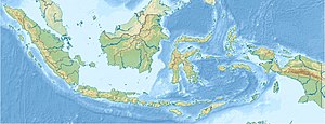
 Map of the Indonesian archipelago | |
| Etymology |
|
| Geography | |
| Location | Southeast Asia and Oceania |
| Adjacent to | |
| Total islands | ± 17,000–18,000 islands[1][2] |
| Major islands | |
| Area | 8,300,000 km2 (3,200,000 sq mi) |
| Highest elevation | 4,884 m (16024 ft)[a] |
| Highest point | Puncak Jaya, Central Papua |
| Administration | |
| President | Joko Widodo |
| Demographics | |
| Demonym | Indonesians |
| Population | ± 280,000,000 (2023) |
| Languages | Over 700 languages |
| Ethnic groups | Over 1,300 ethnic groups |
The Indonesian archipelago (Indonesian: Kepulauan Indonesia) is a vast and diverse collection of over 17,000 to 18,000 islands[3][4] located between the Indian and Pacific Oceans in Southeast Asia and Oceania.[5] It is the world's largest archipelago, with five main islands—Sumatra, Java, Borneo (shared with Malaysia and Brunei), Sulawesi, and New Guinea (shared with Papua New Guinea). The Indonesian archipelago is known for its rich biodiversity, unique wildlife, and varied ecosystems, ranging from tropical rainforests to active volcanoes. The archipelago boasts a diverse cultural heritage, with thousands of ethnic groups and languages. Its strategic location and natural resources have made it a historically significant trade hub and a key player in regional and global affairs. Historically, the Indonesian archipelago was influenced by various cultures and empires, including Hindu and Buddhist kingdoms, Islamic sultanates, and European colonial powers, before gaining independence in 1945 as the state of "Indonesia".
The archipelago comprises around 6,000 inhabited islands, with the remainder being uninhabited.[6] These islands vary in size and significance, from densely populated and culturally influential Java to small, remote islets. Notable islands include Bali, Sumatra, and Komodo Island, each known for specific attributes such as tourism, natural resources, and unique wildlife. The Maluku, or Spice Islands, are historically significant for their role in the global spice trade.[7]
- ^ "Jumlah Pulau Resmi di RI Capai 17.024, Masih Ada yang Tanpa Identitas". cnnindonesia.com (in Indonesian). 2023-11-20. Retrieved 2020-06-19.
- ^ "Indonesia at a Glance". kemlu.com (in Indonesian). 2023-11-20.
- ^ Undang-undang RI Nomor 9 Tahun 1996 tentang Perairan Indonesia [Law No 9/1996 on Maritime Territory of Indonesia] (Law 9, Explanatory notes of Law 9/1996) (in Indonesian). People's Representative Council. 1996.
- ^ Purwanto, Heru, ed. (10 January 2017). "Indonesia to register 14,752 officially named islands with UN". Antara News. Retrieved 19 October 2021.
- ^ Frederick, William H.; Worden, Robert L. (1993). Indonesia: A Country Study. Area Handbook Series. Vol. 550. Washington, D.C.: Federal Research Division, Library of Congress. p. 98. ISBN 9780844407906. Archived from the original on 2023-01-20. Retrieved 9 November 2023.
- ^ "The World Factbook: Indonesia". Central Intelligence Agency. 2018-10-29. Archived from the original on 2021-04-13. Retrieved 2018-11-11.
- ^ "Spices and Their Costs in Medieval Europe". www.economics.utoronto.ca. Archived from the original on 30 October 2020. Retrieved 21 June 2020.
Cite error: There are <ref group=lower-alpha> tags or {{efn}} templates on this page, but the references will not show without a {{reflist|group=lower-alpha}} template or {{notelist}} template (see the help page).