Indur
إندور/عين دور Endor | |
|---|---|
Village | |
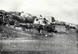
 Indur in the 1890s. | |
| Etymology: Endor[1] | |
A series of historical maps of the area around Indur (click the buttons) | |
Location within Mandatory Palestine | |
| Coordinates: 32°38′11″N 35°22′53″E / 32.63639°N 35.38139°E | |
| Palestine grid | 186/227 |
| Geopolitical entity | Mandatory Palestine |
| Subdistrict | Nazareth |
| Date of depopulation | 24 May 1948[3] |
| Area | |
| • Total | 12,444 dunams (12.4 km2 or 4.8 sq mi) |
| Population (1945) | |
| • Total | 620[2] |
| Cause(s) of depopulation | Military assault by Yishuv forces |
| Secondary cause | Influence of nearby town's fall |
| Current Localities | None |
Indur (Arabic: إندور) was a Palestinian village, located 10.5 kilometres (6.5 mi) southeast of Nazareth. Its name preserves that of ancient Endor, a Canaanite city state thought to have been located 1 kilometre (0.62 mi) to the northeast.[4] The village was depopulated during the 1948 Arab–Israeli War and its inhabitants became refugees, some of whom were internally displaced. In Israel today, there are a few thousand internally displaced Palestinians who hail from Indur, and continue to demand their right of return.


