| International Appalachian Trail | |
|---|---|
 | |
| Length | 2,540 km (1,580 mi) |
| Location | Maine, United States, and Canada |
| Trailheads | Katahdin Woods and Waters National Monument, Maine – Crow Head, Newfoundland and Labrador |
| Use | Hiking |
| Highest point | Mount Katahdin |
| Lowest point | Cap Gaspé |
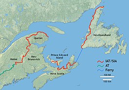
The International Appalachian Trail (IAT; French: Sentier international des Appalaches, SIA) was originally a hiking trail which ran from Katahdin Woods and Waters National Monument, in Maine, through New Brunswick, to the Gaspé Peninsula of Quebec, after which it followed a ferry route to Newfoundland, and then continued to the northern-easternmost point of the Appalachian Mountains at Belle Isle, Newfoundland and Labrador.[2] As of July 2020, there are widely geographically dispersed IAT-branded walking trails in Greenland, Iceland, Norway, Sweden, Denmark, Scotland, Northern Ireland, Ireland, Isle of Man, Wales, England, Spain, Portugal, and Morocco.[3]
- ^ "The Trail". The IAT/SIA Council.
- ^ "Canadian Geographic: International Appalachian Trail Canada 2010".
- ^ "IAT-SIA.org "The Trail" July 2020". Retrieved 2020-07-22.