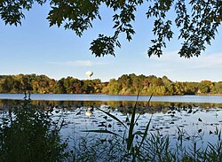
Inver Grove Heights, Minnesota | |
|---|---|
 | |
| Nickname: Inver Grove | |
 Interactive map outlining Inver Grove Heights | |
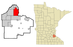
 Location of Inver Grove Heights, Minnesota | |
| Coordinates: 44°50′15″N 93°3′6″W / 44.83750°N 93.05167°W | |
| Country | United States |
| State | Minnesota |
| County | Dakota |
| Established | 1852 |
| Incorporated | March 9, 1965 |
| Government | |
| • Type | Weak Mayor–Council |
| • Mayor | Brenda Dietrich |
| Area | |
| • Total | 30.22 sq mi (78.27 km2) |
| • Land | 27.85 sq mi (72.14 km2) |
| • Water | 2.37 sq mi (6.13 km2) |
| Elevation | 879 ft (268 m) |
| Population | |
| • Total | 35,801 |
| • Estimate (2022)[3] | 35,701 |
| • Density | 1,285.31/sq mi (496.25/km2) |
| Time zone | UTC-6 (Central) |
| • Summer (DST) | UTC-5 (CDT) |
| ZIP codes | 55076, 55077 |
| Area code | 651 |
| FIPS code | 27-31076 |
| GNIS feature ID | 0645437[4] |
| Website | ighmn.gov |
Inver Grove Heights is a city in Dakota County, Minnesota, United States. The population was 35,801 at the 2020 census.[2] The city was formed on March 9, 1965, with the merger of the village of Inver Grove and Inver Grove Township.[5]
It is one of 186 cities and townships in the seven-county Minneapolis-Saint Paul metropolitan area.[6] Inver Grove Heights is 9 miles (14 km) southeast of Saint Paul; nearby communities are South St. Paul, West St. Paul, Sunfish Lake, Eagan, Newport, and Saint Paul Park (the last two across the Mississippi River).
- ^ "2020 U.S. Gazetteer Files". United States Census Bureau. Retrieved July 24, 2022.
- ^ a b "Explorer Census Data". United States Census Bureau. Retrieved August 10, 2022.
- ^ Cite error: The named reference
USCensusEst2022was invoked but never defined (see the help page). - ^ "US Board on Geographic Names". United States Geological Survey. October 25, 2007. Retrieved January 31, 2008.
- ^ Cite error: The named reference
Aboutwas invoked but never defined (see the help page). - ^ Metropolitan Council (May 1, 2008). "Snapshot of the Region". Archived from the original on February 9, 2002. Retrieved September 15, 2008.