This article has multiple issues. Please help improve it or discuss these issues on the talk page. (Learn how and when to remove these messages)
|
Ipiales | |
|---|---|
Municipality and town | |
 Aerial view of Ipiales and Plaza 20 de Julio | |
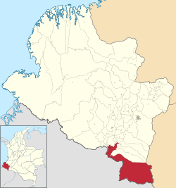
 Location of the municipality and town of Ipiales in the Nariño Department of Colombia. | |
| Coordinates: 0°49′49″N 77°38′40″W / 0.83028°N 77.64444°W | |
| Country | |
| Department | Nariño Department |
| Government | |
| • Mayor | Luis Fernando Villota |
| Area | |
| • Municipality and town | 1,572 km2 (607 sq mi) |
| • Urban | 14.27 km2 (5.51 sq mi) |
| Elevation | 2,898 m (9,508 ft) |
| Population (2018 census)[1] | |
| • Municipality and town | 116,136 |
| • Density | 74/km2 (190/sq mi) |
| • Urban | 77,343 |
| • Urban density | 5,400/km2 (14,000/sq mi) |
| Demonym | Ipialeño |
| Time zone | UTC-5 (Colombia Standard Time) |
| Website | Official website (in Spanish) |
Ipiales is a city and Catholic bishopric in Nariño Department, southern Colombia, near the border with Ecuador. It is located at around 0°49′49″N 77°38′40″W / 0.83028°N 77.64444°W, with an elevation of about 2950 m. Ipiales is located on the high plateau called "Tuquerres e Ipiales," the city lies at a distance of 82 km from Pasto, the department's capital." Ipiales is known as "la ciudad de las nubes verdes" (the city of the green clouds) because sometimes, especially in the afternoon, greenish clouds appear over the city. One of the area's favorite foods is the guinea pig or cavy (Cavia porcellus), called kuy or kuwi.[2] The economy of this city is based on border trade between Ecuador and Colombia.
- ^ Citypopulation.de Population of Ipiales municipality
- ^ Kichwa Yachakukkunapa Shimiyuk Kamu (Ministry of Education, Ecuador)


