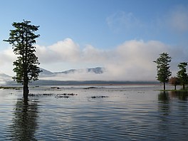
| Lake Ira Lalaro | |
|---|---|
 Lake Ira Lalaro | |
| Coordinates | 8°27′0″S 127°8′0″E / 8.45000°S 127.13333°E |
| Primary outflows | Irasiquero River |
| Basin countries | East Timor |
| Max. length | 6.5 km (4.0 mi) |
| Max. width | 3 km (1.9 mi) |
| Surface area | Average 1.9 km2 (0.73 sq mi) |
| Surface elevation | 318 m (1,043 ft) |
| Settlements | Mehara, Malahara, Poros, Muapitine |
Lake Ira Lalaro (also Iralalaro, Ira-Lalaro, Surubec, Suro Bec) is a freshwater lake in Mehara, Subdistrict Tutuala, Lautém District, East Timor.[1] It is the largest of the island of Timor,[2] and thus too of the country.[3] The lake is part of the Mount Paitchau Important Bird Area.[4] The lake waters and that of Irasiquero River are a closed aquatic system; they lie within a huge polje. It covers between 10–55 square kilometres (3.9–21.2 sq mi) while the authigenic catchment basin covers 406 square kilometres (157 sq mi).[5]
- ^ Miksic, John Norman; Goh, Geok Yian; Connor, Sue O (2011). Rethinking Cultural Resource Management in Southeast Asia: Preservation, Development, and Neglect. Anthem Press. pp. 45–. ISBN 978-0-85728-389-4.
- ^ Asian Perspectives. University Press of Hawaii. 2005. p. 196. Retrieved 27 July 2013.
- ^ Daniel Fitzpatrick (June 2002). Land claims in East Timor. Asia Pacific Press. p. 23. ISBN 978-0-7315-3688-7.
- ^ "TL07 - Important Bird Areas factsheet: Monte Paitchau (proposed Conis Santana National Park)". BirdLife International. Archived from the original on 4 March 2016. Retrieved 27 July 2013.
- ^ White, Susan; White, Nicholas; Middleton, Greg (2006). "Report of findings on the proposed Iralalaro hydro-electric power scheme, Timor-Leste" (PDF). Timor-Leste Institute for Development Monitoring and Analysis. Retrieved 27 July 2013.
