Irrigation Way | |
|---|---|
 | |
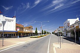
| Leeton's Main Street, part of Irrigation Way | |
 | |
| General information | |
| Type | Rural road |
| Length | 84.8 km (53 mi)[1] |
| Gazetted | December 1929 (as Main Road 254)[2] March 1938 (as Trunk Road 80)[3] |
| Route number(s) | (Yoogali–Griffith) |
| Former route number | (Yoogali–Griffith) |
| Major junctions | |
| Southeast end | Narrandera, New South Wales |
| |
| Northwest end | Griffith, New South Wales |
| Location(s) | |
| Major settlements | Leeton, Widgelli |
| ---- | |
Irrigation Way[4] is a major rural road that runs approximately 85 kilometres (53 mi) through the Murrumbidgee Irrigation Area in south western New South Wales, Australia.
- ^ "Irrigation Way" (Map). Google Maps. Retrieved 1 December 2022.
- ^ "Main Roads Act, 1924-1929". Government Gazette of the State of New South Wales. No. 154. National Library of Australia. 13 December 1929. p. 4917. Archived from the original on 30 November 2022. Retrieved 29 November 2022.
- ^ "Main Roads Act, 1924-1937". Government Gazette of the State of New South Wales. No. 58. National Library of Australia. 14 April 1938. pp. 1525–6. Archived from the original on 29 August 2022. Retrieved 29 August 2022.
- ^ "Road & Street Programs". Narrandera Shire Council. 7 June 2005. Archived from the original on 20 July 2008. Retrieved 25 May 2008.