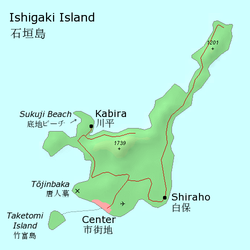
Native name: Ishigaki-jima (石垣島) | |
|---|---|
 | |
| Geography | |
| Location | Pacific Ocean |
| Coordinates | 24°26′N 124°13′E / 24.44°N 124.22°E |
| Archipelago | Yaeyama Islands |
| Area | 222.24[1] km2 (85.81 sq mi) |
| Highest elevation | 525.5 m (1724.1 ft) |
| Highest point | Mount Omoto |
| Administration | |
| Prefecture | Okinawa Prefecture |
| Demographics | |
| Population | 47,564[1] (January 2019) |
| Ethnic groups | Ryukyuan, Japanese |

Ishigaki Island (石垣島, Ishigaki-jima, Yaeyama: Ishanagï, Okinawan: Ishigachi), also known as Ishigakijima, is a Japanese island south-west of Okinawa Hontō and the second-largest island of the Yaeyama Island group, behind Iriomote Island. It is located approximately 411 km (255 mi) south-west of Okinawa Hontō.[1] It is within the City of Ishigaki in Okinawa Prefecture. The city functions as the business and transport center of the archipelago. The island is served by New Ishigaki Airport, the largest airport in the Yaeyamas.
Much of the island and surrounding waters including Mount Omoto and Kabira Bay are protected as part of Iriomote-Ishigaki National Park.[2]
Ishigaki Island, like the rest of Okinawa, is culturally influenced by both Japan and Taiwan due to its location, about 300 km (186 mi) off the north eastern coast of Taiwan.
- ^ a b c "Remote island related materials (離 島 関 係 資 料)" (PDF). Archived (PDF) from the original on 2020-02-15. Retrieved 2020-02-15.
- ^ "Introducing places of interest: Iriomote-Ishigaki National Park (Ishigakijima)". Ministry of the Environment. Archived from the original on 20 April 2012. Retrieved 15 February 2012.
