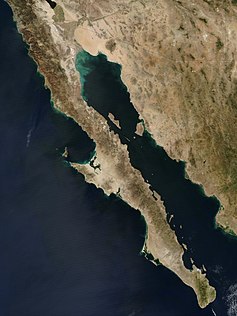


The Island of California (Spanish: Isla de California) refers to the long-held global misconception, dating from the 16th century, that the California region was not part of mainland North America but rather a large island separated from the continent by a strait now known to be the Gulf of California.
One of the most famous cartographic errors in history, it was propagated on many maps during the 17th and 18th centuries, despite contradictory evidence from various explorers.[1] The legend was initially infused with the idea that California was a terrestrial paradise, like the Garden of Eden or Atlantis. This mapping error was not a one-off event. From the mid-1500s to the late 1700s[2] great controversy surrounded the geography of California. For instance, a Spanish map from 1548 depicts California as a peninsula,[3] while a 1622 Dutch map depicts California as an island.[citation needed] A 1626 Portuguese map depicts the land as a peninsula,[citation needed] while a 1630 British map depicts it as an island.[4] A French map from 1682 only shows the tip of the Baja Peninsula.[citation needed] There are slightly over 1,000 maps in Stanford's Glen McLaughlin Collection of California as an Island, the largest collection of such maps in the world.[5]
- ^ "History". California as an Island in Maps - Spotlight at Stanford. February 7, 2016. Retrieved February 9, 2023.
- ^ Leighly, John, Robert Grabhorn, and Andrew Hoyem. California As an Island: An Illustrated Essay. San Francisco, [Calif.: Book Club of California, 1972. Print.
- ^ Gastaldi, Giacomo (1548). Map of California. Glen McLaughlin Collection of California as an Island. McLaughlin map number 1189. Green Library, Stanford University, Stanford, CA.
- ^ Briggs, Henry (1625). Map of California. Glen McLaughlin Collection of California as an Island. McLaughlin map number 2. Green Library, Stanford University, Stanford, CA.
- ^ McLaughlin, Glen. Glen McLaughlin Collection of California as an Island, Stanford Libraries. Accessed 15 Feb. 2023.