| Isyk-Kul | |
|---|---|
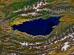
 Issyk-Kul from space, September 1992 | |
| Coordinates | 42°25′N 77°15′E / 42.417°N 77.250°E |
| Lake type | Ancient lake, Endorheic Mountain lake Monomictic |
| Primary inflows | Glaciers |
| Primary outflows | Evaporation |
| Catchment area | 15,844 square kilometres (6,117 sq mi) |
| Basin countries | Kyrgyzstan |
| Max. length | 178 kilometres (111 mi)[1] |
| Max. width | 60.1 kilometres (37.3 mi)[1] |
| Surface area | 6,236 square kilometres (2,408 sq mi)[1] |
| Average depth | 278.4 metres (913 ft)[1] |
| Max. depth | 668 metres (2,192 ft)[1][2] |
| Water volume | 1,736 cubic kilometres (416 cu mi)[3][2] |
| Residence time | ~330 years[2] |
| Salinity | 6g/L[1][2] |
| Shore length1 | 669 kilometres (416 mi)[1] |
| Surface elevation | 1,607 metres (5,272 ft)[1] |
| Settlements | Balykchy, Cholpon-Ata, Karakol |
| Official name | The Issyk-kul State Nature Reserve with the Issyk-kul Lake |
| Designated | 12 November 2002 |
| Reference no. | 1231[4] |
| 1 Shore length is not a well-defined measure. | |
Issyk-Kul (Russian: Иссык-Куль) or Ysyk-Köl (Kyrgyz: Ысык-Көл, [ɯsɯq kœl], "Warm Lake") is an endorheic (i.e., without outflow) saline lake in the western Tianshan Mountains in eastern Kyrgyzstan, just south of a dividing range separating Kyrgyzstan from Kazakhstan. It is the eighth-deepest lake in the world, the eleventh-largest lake in the world by volume (though not in surface area), the deepest lake whose deepest point is above sea level (939 meters or 3,080 feet), and the third-largest saline lake. Issyk-Kul means "warm lake" in the Kyrgyz language; although it is located at a lofty elevation of 1,607 metres (5,272 ft) and subject to severe cold during winter, it rarely freezes over due to high salinity.[5][6]
The lake is a Ramsar site of globally significant biodiversity[7] and forms part of the Issyk-Kul Biosphere Reserve.
- ^ a b c d e f g h Savvaitova, K.; Petr, T. (December 1992), "Lake Issyk-Kul, Kirgizia", International Journal of Salt Lake Research, 1 (2): 21–46, doi:10.1007/BF02904361
- ^ a b c d Hofer, Markus; Peeters, Frank; Aeschbach-Hertig, Werner; Brennwald, Matthias; Holocher, Johannes; Livingstone, David M.; Romanovski, Vladimir; Kipfer, Rolf (11 July 2002), "Rapid deep-water renewal in Lake Issyk-Kul (Kyrgyzstan) indicated by transient tracers", Limnology and Oceanography, 4 (47): 1210–1216, doi:10.4319/lo.2002.47.4.1210
- ^ Kodayev, G.V. (1973), "Морфометрия озера Иссык-Куль" [Morphometry of Lake Issyk-Kul], News of the All-Union Geographic Society (Izvestiya VGO) (in Russian)
- ^ "The Issyk-kul State Nature Reserve with the Issyk-kul Lake". Ramsar Sites Information Service. Retrieved 25 April 2018.
- ^ Nihoul, Jacques C.J.; Zavialov, Peter O.; Micklin, Philip P. (2012). Dying and Dead Seas Climatic Versus Anthropic Causes. Springer Science+Business Media. p. 21. ISBN 9789400709676. Retrieved 4 December 2015.
- ^ "Extreme cold weather freezes Issyk-Kul lake | Copernicus". www.copernicus.eu. Retrieved 2023-06-10.
- ^ Ramsar Site RDB Code 2KG001


