Istachatta, Florida | |
|---|---|
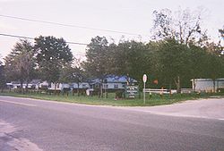
 The Istachatta community center and Hernando County Public Library on the corner of CR 439 and Magnon Drive | |
 Location in Hernando County and the state of Florida | |
| Coordinates: 28°39′44″N 82°16′37″W / 28.66222°N 82.27694°W | |
| Country | United States |
| State | Florida |
| County | Hernando |
| Area | |
| • Total | 0.35 sq mi (0.91 km2) |
| • Land | 0.31 sq mi (0.79 km2) |
| • Water | 0.05 sq mi (0.12 km2) |
| Elevation | 59 ft (18 m) |
| Population (2020) | |
| • Total | 126 |
| • Density | 411.76/sq mi (158.91/km2) |
| Time zone | UTC-5 (Eastern (EST)) |
| • Summer (DST) | UTC-4 (EDT) |
| ZIP code | 34636 |
| Area code | 352 |
| FIPS code | 12-34275[2] |
| GNIS feature ID | 0284632[3] |
Istachatta is an unincorporated community and census-designated place (CDP) in Hernando County, Florida, United States. The population was 116 at the 2010 census,[4] up from 65 at the 2000 census. The name "Istachatta" is derived from a Seminole word meaning "man snake".[5]
- ^ "2020 U.S. Gazetteer Files". United States Census Bureau. Retrieved October 31, 2021.
- ^ "U.S. Census website". United States Census Bureau. Retrieved January 31, 2008.
- ^ "US Board on Geographic Names". United States Geological Survey. October 25, 2007. Retrieved January 31, 2008.
- ^ "Geographic Identifiers: 2010 Demographic Profile Data (G001): Istachatta CDP, Florida". American Factfinder. U.S. Census Bureau. Retrieved April 27, 2017.[dead link]
- ^ Gannett, Henry (1905). The Origin of Certain Place Names in the United States. Govt. Print. Off. pp. 167.