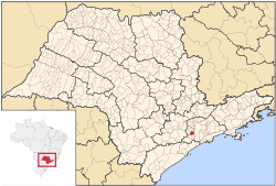
Itapecerica da Serra | |
|---|---|
Municipality | |
 | |
 Location in São Paulo state | |
| Coordinates: 23°43′2″S 46°50′58″W / 23.71722°S 46.84944°W | |
| Country | |
| Region | Southeast Brazil |
| State | São Paulo |
| Metropolitan Region | São Paulo |
| Area | |
| • Total | 150.74 km2 (58.20 sq mi) |
| Elevation | 920 m (3,020 ft) |
| Population (2020 [1]) | |
| • Total | 177,662 |
| • Density | 1,200/km2 (3,100/sq mi) |
| Time zone | UTC−3 (BRT) |
Itapecerica da Serra (Portuguese pronunciation: [itapeˈsɛɾikɐ dɐ ˈsɛʁɐ]) is a municipality in the Brazilian state of São Paulo. It is part of the Metropolitan Region of São Paulo.[2] The population is 177,662 (2020 est.) in an area of 150.74 km2 (58.20 sq mi).[3] It is located 23 miles southwest of São Paulo and at an altitude of 920 m (3,020 ft) above sea level. The name Itapecerica is believed to come from the Tupi language for slippery stone, and da Serra means of the Mountains in Portuguese.
- ^ IBGE 2020
- ^ "Lei Complementar 1139/11 | Lei Complementar nº 1.139, de 16 de junho de 2011, Governo do Estado de São Paulo". 2014-03-01. Archived from the original on 2014-03-01. Retrieved 2023-05-19.
- ^ "IBGE | Cidades | São Paulo | Itapecerica da Serra". 2015-10-08. Archived from the original on 2015-10-08. Retrieved 2023-05-19.


