| Itasca State Park | |
|---|---|
IUCN category IV (habitat/species management area) | |
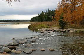
 The headwaters of the Mississippi River in Itasca State Park | |
| Location | Minnesota, United States |
| Coordinates | 47°14′23″N 95°12′27″W / 47.23972°N 95.20750°W |
| Area | 32,690 acres (132.3 km2) |
| Elevation | 1,558 ft (475 m)[1] |
| Established | 1891 |
| Governing body | Minnesota Department of Natural Resources |
Itasca State Park (/aɪˈtæskə/) is a state park of Minnesota, United States, and contains the headwaters of the Mississippi River. The park spans 32,690 acres (132.3 km2) of northern Minnesota, and is located about 21 miles (34 km) north of Park Rapids, Minnesota and 25 miles (40 km) from Bagley, Minnesota. The park is part of Minnesota's Pine Moraines and Outwash Plains Ecological Subsection and is contained within Clearwater, Hubbard, and Becker counties.[2]
Itasca State Park was established by the Minnesota Legislature on April 20, 1891, making it the first of Minnesota's state parks and second oldest in the United States, behind Niagara Falls State Park. Henry Schoolcraft determined Lake Itasca as the river's source in 1832. It was named as a National Natural Landmark in 1965, and was added to the National Register of Historic Places in 1973. About 500,000 people visit Itasca State Park annually.
- ^ "Itasca State Park". Geographic Names Information System. United States Geological Survey. January 11, 1980. Retrieved February 25, 2011.
- ^ Cite error: The named reference
snowwas invoked but never defined (see the help page).

