Iwanuma
岩沼市 | |
|---|---|
 Takekoma Shrine, Kanahebisui Shrine Abukuma River, Iwanuma Station Iwanuma urban area, Dontosai festival | |
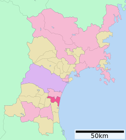
 Location of Iwanuma in Miyagi Prefecture | |
| Coordinates: 38°06′15.4″N 140°52′12.6″E / 38.104278°N 140.870167°E | |
| Country | Japan |
| Region | Tōhoku |
| Prefecture | Miyagi |
| First official recorded | 842 AD |
| City settled | November 1, 1971 |
| Government | |
| • Mayor | Jyunichi Sato (from June 2022) |
| Area | |
| • Total | 60.45 km2 (23.34 sq mi) |
| Population (May 31, 2020) | |
| • Total | 43,946 |
| • Density | 730/km2 (1,900/sq mi) |
| Time zone | UTC+9 (Japan Standard Time) |
| - Tree | Japanese Black Pine |
| - Flower | Azalea |
| - Bird | Seagull |
| Phone number | 0223-22-1111 |
| Address | 1-6-20 Sakura, Iwanuma-shi, Miyagi-ken 989-2480 |
| Website | Official website |

Iwanuma (岩沼市, Iwanuma-shi) is a city located in Miyagi Prefecture, Japan. As of 31 March 2020[update], the city had an estimated population of 43,946 in 18,062 households,[1] and a population density of 730 persons per km². The total area of the city is 60.45 square kilometres (23.34 sq mi). Iwanuma is at the convergence of two ancient roads, the Tōkaidō and the Rikuzen-Hama Kaidō.
- ^ Iwanuma city official statistics(in Japanese)


