Jackson Parish | |
|---|---|
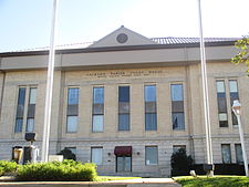
 Jackson Parish Courthouse in Jonesboro | |
 Location within the U.S. state of Louisiana | |
 Louisiana's location within the U.S. | |
| Coordinates: 32°18′N 92°33′W / 32.3°N 92.55°W | |
| Country | |
| State | |
| Founded | 1845 |
| Named for | Andrew Jackson |
| Seat | Jonesboro |
| Largest town | Jonesboro |
| Area | |
| • Total | 580 sq mi (1,500 km2) |
| • Land | 569 sq mi (1,470 km2) |
| • Water | 11 sq mi (30 km2) 1.9% |
| Population (2020) | |
| • Total | 15,031 |
| • Estimate (2021) | 14,876 |
| • Density | 26/sq mi (10/km2) |
| Time zone | UTC−6 (Central) |
| • Summer (DST) | UTC−5 (CDT) |
| Congressional district | 5th |
| Website | www |
Jackson Parish (French: Paroisse de Jackson) is a parish in the northern part of the U.S. state of Louisiana. As of the 2020 census, the population was 15,031.[1] The parish seat is Jonesboro.[2] The parish was formed in 1845 from parts of Claiborne, Ouachita, and Union Parishes. In the twentieth century, this part of the state had several small industrial mill towns, such as Jonesboro. East of Jonesboro is the Jimmie Davis State Park, which includes Caney Lake Reservoir.
- ^ "State & County QuickFacts". United States Census Bureau. Retrieved September 7, 2022.
- ^ "Find a County". National Association of Counties. Archived from the original on May 31, 2011. Retrieved June 7, 2011.