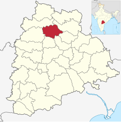
Jagtial district | |
|---|---|
 Lakshmi Narasimha Swami temple, Dharmapuri | |
 Location in Telangana | |
| Coordinates (Jagtial): 18°42′N 78°54′E / 18.7°N 78.9°E | |
| Country | |
| State | Telangana |
| Headquarters | Jagtial |
| Mandalas | 18 |
| Government | |
| • District Collector | Shaik Yasmeen Basha |
| • Parliament constituencies | Nizamabad |
| • Assembly constituencies | Jagtial, Korutla, Dharmapuri |
| Area | |
| • Total | 2,419.00 km2 (933.98 sq mi) |
| Population (2011) | |
| • Total | 988,913 |
| • Density | 410/km2 (1,100/sq mi) |
| Time zone | UTC+05:30 (IST) |
| Vehicle registration | TG 21 |
| Website | jagtial |
Jagtial district is a district located in the northern region of the Indian state of Telangana.[1] Its administrative headquarters is the city of Jagtial. The district shares boundaries with Nirmal, Mancherial, Karimnagar, Peddapalli, Sircilla and Nizamabad districts.[2][3]
- ^ "Jagtial district" (PDF). Official website of Jagtial district. Archived from the original (PDF) on 10 January 2017. Retrieved 29 June 2017.
- ^ "Jagtial district" (PDF). Chief Commissioner of Land Administration. Archived from the original (PDF) on 9 September 2016. Retrieved 22 August 2016.
- ^ "New districts map". newdistrictsformation.telangana.gov.in. Retrieved 22 August 2016.[permanent dead link]
