| Jayakwadi Dam | |
|---|---|
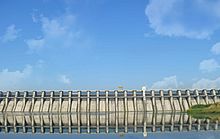
 Jayakwadi dam with its floodgates closed | |
| Official name | Jayakwadi-I D02995 |
| Location | Jayakwadi, Aurangabad District, Maharashtra, India |
| Coordinates | 19°29′8.7″N 75°22′12″E / 19.485750°N 75.37000°E |
| Construction began | 1965 |
| Opening date | 1976[1] |
| Construction cost | 4,700 cr[2] |
| Owner(s) | Government of Maharashtra |
| Dam and spillways | |
| Type of dam | Earthen dam |
| Impounds | Godavari River |
| Height | 41.30 m (135 ft) |
| Length | 9,998 m (32,802 ft) (9.998 km) |
| Spillways | 27 Gates |
| Spillway capacity | 18153 cubic meters/sec[3] |
| Reservoir | |
| Creates | Nath Sagar Jalashay |
| Total capacity | 2.909 km3 (1.027×10¹¹ cu ft) (102.75 tmc ft)[4] |
| Active capacity | 2.17 cubic kms (77 tmc ft)[5] |
| Inactive capacity | 26 tmc ft |
| Catchment area | 21,750 km2 (8,398 sq mi) |
| Surface area | 350 km2 (135 sq mi) |
| Power Station | |
| Installed capacity | 12 MW |
Jayakwadi dam is an earthen dam located on Godavari river at the site of Jayakwadi village in Paithan taluka of Aurangabad district in Maharashtra, India. It is a multipurpose project. The water is mainly used to irrigate agricultural land in the drought-prone Marathwada region of the state. It also provides water for drinking and industrial usage to nearby towns and villages and to the municipalities and industrial areas of Sambhajinagar and Jalna districts. The surrounding area of the dam has a garden and a bird sanctuary.
- ^ "Jayakwadi-I D02995". Retrieved 1 March 2016.
- ^ "Jaikwadi Dam and Its Nath Sagar Reservoir". authorstream.com. Archived from the original on 10 February 2020. Retrieved 13 September 2013.
- ^ Dams of national importance, National Register of large dams,2019 Ed, Central Water Commission, New Delhi, Govt of India
- ^ Dams of national importance, National Register of large dams,2019 Ed, Central Water Commission, New Delhi, Govt of India
- ^ Dams of national importance, National Register of large dams, 2019 Ed, Central Water Commission, New Delhi, Govt of India
