Jayapura | |
|---|---|
| City of Jayapura Kota Jayapura | |
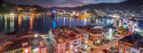
Panoramic view of Jayapura Jayapura City signboard Jayapura Port within Humboldt Bay Mal Jayapura Mal Jayapura, and Jayapura City view at night | |
| Motto(s): Hen Tecahi Yo Onomi, T'mar Ni Hanased (One Heart Builds a City for God's Glory) | |
 Location in Papua Province | |
Location in Indonesian Papua Location in Indonesia | |
| Coordinates: 2°31′58.8″S 140°43′1.2″E / 2.533000°S 140.717000°E | |
| Country | |
| Region | Papua |
| Province | |
| Founded | 7 March 1910 (as Hollandia)[1] |
| Incorporated | 2 August 1993[2] |
| Government | |
| • Mayor | Benhur Tomi Mano |
| • Vice Mayor | Rustan Saru |
| Area | |
| • Total | 940.0 km2 (362.9 sq mi) |
| Elevation | 287 m (942 ft) |
| Population (mid 2023 estimate[3]) | |
| • Total | 414,862 |
| • Density | 440/km2 (1,100/sq mi) |
| Time zone | UTC+9 (Indonesia Eastern Time) |
| Area code | (+62) 967 |
| Climate | Af |
| HDI | |
| Website | jayapurakota |
Jayapura (formerly Hollandia) is the capital and largest city of the Indonesian province of Papua. It is situated on the northern coast of New Guinea island and covers an area of 940.0 km2 (362.9 sq mi). The city borders the Pacific Ocean and Yos Sudarso Bay to the north, the country of Papua New Guinea to the east, Keerom Regency to the south, and Jayapura Regency to the west.
With a population of 398,478 according to the 2020 census,[4] Jayapura is the most populous city in the entire island of New Guinea, surpassing Port Moresby, the national capital and largest city of Papua New Guinea.[5] During the 2010-2020 decade it was also the fastest-growing city in Indonesia, with the population increasing by 55.23% between 2010 and 2020.[6] The official estimate as at mid 2023 was 414,862 (comprising 220,024 males and 194,838 females).[3]
Jayapura is the fourth largest city by economy in Eastern Indonesia—after Makassar, Denpasar, and Manado—with an estimated 2016 GDP at Rp19.48 trillion.[7] Jayapura has a very high Human Development Index (HDI) at 0.801.[8]
- ^ "Sejarah Singkat Kota Jayapura – Dinas Komunikasi Dan Informatika". Archived from the original on 2 February 2020. Retrieved 2 February 2020.
- ^ RI, Setjen DPR. "J.D.I.H. - Dewan Perwakilan Rakyat". www.dpr.go.id. Archived from the original on 28 July 2020. Retrieved 2 February 2020.
- ^ a b Badan Pusat Statistik, Jakarta, 28 February 2024, Kota Jayapura Dalam Angka 2024 (Katalog-BPS 1102001.9171)
- ^ Badan Pusat Statistik, Jakarta, 2021.
- ^ "Badan Pusat Statistik".
- ^ Biro Pusat Statistik, Jakarta, 2011.
- ^ Badan Pusat Statistik (2017). Produk Domestik Regional Bruto Kabupaten/Kota di Indonesia 2012-2016. Jakarta: Badan Pusat Statistik.
- ^ "Badan Pusat Statistik".


