Jeffersonville, Indiana | |
|---|---|
| City of Jeffersonville | |
 Skyline of Jeffersonville | |
| Nickname: Jeff | |
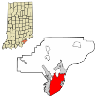
 Location of Jeffersonville in Clark County, Indiana | |
| Coordinates: 38°20′15″N 85°42′09″W / 38.33750°N 85.70250°W | |
| Country | United States |
| State | Indiana |
| County | Clark |
| Established | 1801 |
| Government | |
| • Mayor | Mike Moore (R)[citation needed] |
| Area | |
• Total | 34.35 sq mi (88.97 km2) |
| • Land | 34.08 sq mi (88.26 km2) |
| • Water | 0.28 sq mi (0.71 km2) |
| Elevation | 538 ft (164 m) |
| Population (2020) | |
• Total | 49,447 |
| • Density | 1,451.04/sq mi (560.26/km2) |
| Time zone | UTC−5 (EST) |
| • Summer (DST) | UTC−4 (EDT) |
| ZIP codes | 47130, 47131, and 47199 |
| Area code(s) | 812 & 930 |
| FIPS code | 18-38358[3] |
| GNIS feature ID | 2395463[2] |
| Website | cityofjeff |
Jeffersonville is a city and the county seat of Clark County, Indiana, United States,[4] situated along the Ohio River. Locally, the city is often referred to by the abbreviated name Jeff. It lies directly across the Ohio River to the north of Louisville, Kentucky, along I-65. The population was 49,447 at the 2020 census.[5]
Jeffersonville began its existence as a settlement around Fort Finney after 1786 and was named after Thomas Jefferson in 1801, the year he took office.
- ^ "2020 U.S. Gazetteer Files". United States Census Bureau. Archived from the original on March 18, 2021. Retrieved March 16, 2022.
- ^ a b U.S. Geological Survey Geographic Names Information System: Jeffersonville, Indiana
- ^ "U.S. Census website". United States Census Bureau. Archived from the original on July 9, 2021. Retrieved January 31, 2008.
- ^ "Find a County". National Association of Counties. Archived from the original on May 3, 2015. Retrieved June 7, 2011.
- ^ "U.S. Census Bureau QuickFacts: Jeffersonville city, Indiana". census.gov. Archived from the original on January 28, 2024. Retrieved June 10, 2022.


