Jersey County | |
|---|---|
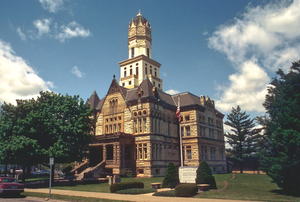
 Jersey County Courthouse in Jerseyville | |
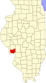
 Location within the U.S. state of Illinois | |
 Illinois's location within the U.S. | |
| Coordinates: 39°05′N 90°22′W / 39.09°N 90.36°W | |
| Country | |
| State | |
| Founded | February 28, 1839 |
| Named for | New Jersey |
| Seat | Jerseyville |
| Largest city | Jerseyville |
| Area | |
| • Total | 377 sq mi (980 km2) |
| • Land | 369 sq mi (960 km2) |
| • Water | 7.9 sq mi (20 km2) 2.1% |
| Population (2020) | |
| • Total | 21,512 |
| • Density | 57/sq mi (22/km2) |
| Time zone | UTC−6 (Central) |
| • Summer (DST) | UTC−5 (CDT) |
| Congressional district | 15th |
| Website | www |
Jersey County is a county located in the U.S. state of Illinois. At the 2020 census, it had a population of 21,512.[1] The county seat and largest community is Jerseyville, with a population of 8,337 in 2010.[2] The county's smallest incorporated community is Otterville, with a population of 87.
Jersey County is included in the St. Louis, MO-IL Metropolitan Statistical Area.
- ^ "State & County QuickFacts". United States Census Bureau. Archived from the original on June 6, 2011. Retrieved July 6, 2014.
- ^ "Find a County". National Association of Counties. Archived from the original on May 9, 2015. Retrieved June 7, 2011.