Jimsar County
Jimasa; Fuyuan | |
|---|---|
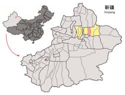
 Location of Jimsar County (pink) in Changji Prefecture (yellow) and Xinjiang (light grey) | |
| Coordinates: 43°59′N 89°04′E / 43.983°N 89.067°E | |
| Country | China |
| Autonomous region | Xinjiang |
| Autonomous prefecture | Changji |
| Township-level divisions | 4 towns 4 townships |
| County seat | Jimsar Town |
| Area | |
| • Total | 8,140.84 km2 (3,143.20 sq mi) |
| Population (2020)[1] | |
| • Total | 153,197 |
| • Density | 19/km2 (49/sq mi) |
| Time zone | UTC+8 (China Standard[a]) |
| Website | www |
| Jimsar County | |||||||||||
|---|---|---|---|---|---|---|---|---|---|---|---|
| Chinese name | |||||||||||
| Simplified Chinese | 吉木萨尔县 | ||||||||||
| Traditional Chinese | 吉木薩爾縣 | ||||||||||
| |||||||||||
| Alternative Chinese name | |||||||||||
| Simplified Chinese | 孚远县 | ||||||||||
| Traditional Chinese | 孚遠縣 | ||||||||||
| |||||||||||
| Uyghur name | |||||||||||
| Uyghur | جىمىسار ناھىيىسى | ||||||||||
| |||||||||||
Jimsar County is a county in Changji Hui Autonomous Prefecture, Xinjiang, China. It contains an area of 8,149 km2 (3,146 sq mi). According to the 2002 census, it has a population of 130,000.
Near the town of Jimsar are the ruins of the ancient city of Beiting (Chinese: 北庭; pinyin: Běitíng) or Ting Prefecture (Chinese: 庭州; pinyin: Tíngzhōu), the headquarters of the Beiting Protectorate during the 8th century. It was later known as Beshbalik (Chinese: 别失八里) and became one of the capitals of the Uyghur Khaganate and then the Kingdom of Qocho.
Cite error: There are <ref group=lower-alpha> tags or {{efn}} templates on this page, but the references will not show without a {{reflist|group=lower-alpha}} template or {{notelist}} template (see the help page).


