| Jinsha Yangtze (长江) | |
|---|---|
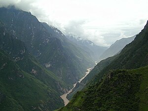
 Jinsha flowing along the bottom of Tiger Leaping Gorge | |
 Map of the Jinsha River drainage basin | |
| Etymology | Chinese: "Gold Dust River"[1] |
| Native name | 金沙江 |
| Location | |
| Country | China |
| State | Qinghai, Tibet Autonomous Region, Yunnan, Sichuan |
| Cities | Lijiang, Yunnan, Panzhihua |
| Physical characteristics | |
| Source | Tongtian River |
| • location | Confluence of the Tongtian and Batang Rivers, Qinghai |
| • coordinates | 34°5′38.8″N 92°54′46.1″E / 34.094111°N 92.912806°E |
| • elevation | 4,500 m (14,800 ft) |
| Mouth | Yangtze River |
• location | Confluence with Min Jiang at Yibin, Sichuan |
• coordinates | 28°46′13.4″N 104°37′58.1″E / 28.770389°N 104.632806°E |
• elevation | 300 m (980 ft) |
| Length |
|
| Basin size | 485,000 km2 (187,000 sq mi)approx. |
| Discharge | |
| • average | 4,471 m3/s (157,900 cu ft/s) |
| • maximum | 35,000 m3/s (1,200,000 cu ft/s) |
| Basin features | |
| Progression | Yangtze → East China Sea |
| River system | Yangtze River basin |
| Tributaries | |
| • left | Beilu River, Yalong River |
| • right | Pudu River, Dadan River, Xiaojiang River, Niulan River |
The Jinsha River (Chinese: 金沙江; pinyin: Jīnshājiāng; lit. 'Gold Sand River',[1] Tibetan: Dri Chu, འབྲི་ཆུ, Yi: ꀉꉷꏁꒉ, romanized: Axhuo Shyxyy) or Lu river, is the Chinese name for the upper stretches of the Yangtze River. It flows through the provinces of Qinghai, Sichuan, and Yunnan in western China. The river passes through Tiger Leaping Gorge.
It is sometimes grouped together with the Lancang (upper Mekong) and Nu (upper Salween) as the Sanjiang ("Three Rivers") area,[2] part of which makes up the Three Parallel Rivers of Yunnan Protected Areas.
The river is important in generating hydroelectric power, and several of the world's largest hydroelectric power stations are on the Jinsha river.