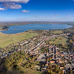
Joachimsthal | |
|---|---|
 | |
Location of Joachimsthal within Barnim district  | |
| Coordinates: 52°58′N 13°45′E / 52.967°N 13.750°E | |
| Country | Germany |
| State | Brandenburg |
| District | Barnim |
| Municipal assoc. | Joachimsthal (Schorfheide) |
| Government | |
| • Mayor (2024–29) | René Knaak-Reichstein[1] (CDU) |
| Area | |
| • Total | 120.18 km2 (46.40 sq mi) |
| Elevation | 72 m (236 ft) |
| Population (2022-12-31)[2] | |
| • Total | 3,446 |
| • Density | 29/km2 (74/sq mi) |
| Time zone | UTC+01:00 (CET) |
| • Summer (DST) | UTC+02:00 (CEST) |
| Postal codes | 16247 |
| Dialling codes | 033361 |
| Vehicle registration | BAR |
| Website | www.joachimsthal.de |
is a small town in the district of Barnim, in Brandenburg, Germany. It is situated within the Schorfheide-Chorin Biosphere Reserve on the isthmus between the lakes Grimnitzsee in the north and Werbellinsee in the south, about 17 km (11 mi) northwest of the district's capital Eberswalde and 55 km (34 mi) northeast of the Berlin city centre. The municipality is the administrative seat of the Amt ("collective municipality") Amt Joachimsthal.
- ^ Landkreis Barnim Wahl der Bürgermeisterin / des Bürgermeisters. Retrieved 27 June 2024.
- ^ "Bevölkerungsentwicklung und Bevölkerungsstandim Land Brandenburg Dezember 2022" (PDF). Amt für Statistik Berlin-Brandenburg (in German). June 2023.


