| Johnson's Shut-Ins State Park | |
|---|---|
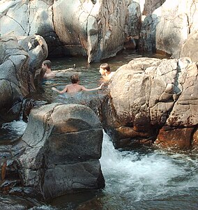
 A portion of the park's natural water park pictured after the 2009 reopening | |
| Location | Reynolds County, Missouri, United States |
| Coordinates | 37°32′14″N 90°51′01″W / 37.53722°N 90.85028°W[1] |
| Area | 8,780.51 acres (35.5335 km2)[2] |
| Elevation | 1,106 ft (337 m)[1] |
| Designation | Missouri state park |
| Established | 1955[3] |
| Visitors | 373,204 (in 2017)[2] |
| Administrator | Missouri Department of Natural Resources |
| Website | Johnson's Shut-Ins State Park |
Johnson's Shut-Ins State Park is a public recreation area covering 8,781 acres (3,554 ha) on the East Fork Black River in Reynolds County, Missouri. The state park is jointly administered with adjoining Taum Sauk Mountain State Park, and together the two parks cover more than sixteen thousand acres in the St. Francois Mountains region of the Missouri Ozarks.[4]
The term "shut-in" refers to a place where the river's breadth is limited by hard rock that is resistant to erosion. In these shut-ins, the river cascades over and around smooth-worn igneous rock, creating a natural water park that is used by park visitors when water levels are not dangerously high.[5]
- ^ a b "Johnson's Shut-Ins State Park". Geographic Names Information System. United States Geological Survey, United States Department of the Interior.
- ^ a b Cite error: The named reference
parkdatawas invoked but never defined (see the help page). - ^ Cite error: The named reference
acquisitionwas invoked but never defined (see the help page). - ^ Cite error: The named reference
parkswas invoked but never defined (see the help page). - ^ Cite error: The named reference
parks3was invoked but never defined (see the help page).

