| Jomolhari | |
|---|---|
| Chomo Lhari | |
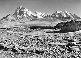
 Jomolhari seen from the southwest Picture taken in Phari, Tibet, in 1938 | |
| Highest point | |
| Elevation | 7,326 m (24,035 ft)[1] Ranked 79th |
| Prominence | 2,077 m (6,814 ft) |
| Listing | Ultra |
| Coordinates | 27°49′27″N 89°16′12″E / 27.82417°N 89.27000°E |
| Naming | |
| English translation | Mountain of the Goddess |
| Language of name | Tibetan |
| Geography | |
| Location | Paro, Bhutan Tibet Autonomous Region, China |
| Parent range | Himalaya |
| Climbing | |
| First ascent | May 1937 |
Jomolhari or Chomolhari[2] (Wylie: jo mo lha ri; sometimes known as "the bride of Kangchenjunga”, is a mountain in the Himalayas, straddling the border between Yadong County of Tibet, China and the Paro district of Bhutan. The north face rises over 2,700 metres (8,900 ft) above the barren plains. The mountain is the source of the Paro Chu (Paro river) which flows from the south side and the Amo Chu which flows from the north side.
